January 27, 2014

On Lake George, from the deck of the survey ship Mintaka, the threat to boats cruising past Shelving Rock near The Narrows is apparent in high resolution detail. Lurking beneath the water, where charts indicate consistent (if shallow) water, are intermittent formations of jagged hull-ripping rock ledge. Although the educated boater would be warned from these shores by well-placed channel markers, the moral of the story stands: there's a lot we still don't know about Lake George.
In the coming years we are going to learn a great deal more, thanks to the Jefferson Project at Lake George, a multi-million dollar collaboration between RPI, IBM, and the FUND for Lake George that will develop a suite of new technologies and techniques to revolutionize environmental monitoring.
The partnership launched in June, 2013, and an in-depth survey of the Lake George watershed was among the first tasks on the agenda. A few weeks ago, I had a chance to ride aboard the Mintaka – one of two boats (and an airplane) that are completing the survey through contractor Substructure– with Sandra Nierzwicki-Bauer, director of the RPI Darrin Fresh Water Institute on Lake George.
The survey is critical to the development of an accurate computer model of water circulation in Lake George, a model that will help researchers, policy makers, and the public, understand how water, nutrients, invasive species, and pollutants move through the watershed and within Lake George. The survey will provide information on bathymetry (the bottom profile) and backscatter, which indicates the composition of the lake bed ... but more on that later.
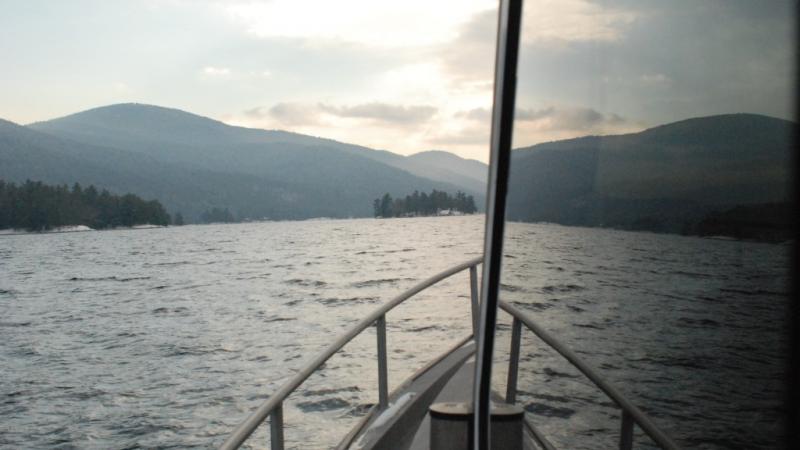
From the dock, Mintaka resembles a lobster boat, albeit one bristling with communication and radar antennas. But step into the climate controlled cabin, and any thought of dinner is displaced by an array of computer monitors displaying data streaming in from two keel-mounted multibeam sonar units. Tom Reis, president of Substructure, and captain of the Mintaka, explained that a cell chip communicating with a GPS monitor on shore tracks the real time position of the boat, and hence the data being collected, to within one centimeter.
Reis said that sonar can be adapted for many purposes depending on the wavelength of sound used, pulse power, pulse width, the depth at which the array is towed, the quality of the sonar heads, and the software used to process the information:
The best way to think of most sonar systems is like a fixed focus camera. A picture taken of a car 20- feet away will be much crisper than a car 200 feet away. You can digitally zoom in on the car 200 feet away but it doesn't really make the picture clearer, it just enhances the pixels size. The same is true for acoustic sonar systems. They are all basically fixed focus cameras on the bottom of the boat and the depth of water in one of the main determining factors in the resolution.
That said, the frequency of the system determines the overall range resolution. The shorter the wave length (higher frequency) the better the resolution. The down side is that, the shorter the wave length, the greater the acoustic absorption. Meaning that the acoustic energy is absorbed quickly as the acoustic pulse pushes through the water. So higher frequencies produce better resolution at short distances, and lower frequencies penetrate further but at lower resolution.
Subustructure assembled its system for this project with the aim of providing the best possible information on bathymetry and backscatter in one survey of Lake George. Through most of the lake, the boats will collect one sounding (ping) for 50 centimeters square, dividing the lake into about 1.5 billion grid blocks.
As the Mintaka cruises the surface, Bill Jenkins of Substructure monitors the incoming images and calibrates the position, range, saturation, and backscatter of each sonar unit independently. Each unit collects information on a broad swath of the lake bed, and Jenkins must monitor the equipment continuously to get the best possible image depending on the depth of the water and the composition of the lake bottom.
For example, although the units themselves are fixed, Jenkins can collect data from directly underneath the boat or from an angle to either side. Depending on the depth, he adjusts the data being collected so that the two data streams provide the broadest possible swath of information without overlapping. Close to the lakeshore he pitches off to the side to collect data from the lake bed – and those vicious rocks off of Shelving Rock – as it rises towards the surface.
Jenkins must also monitor the power of the signal emanating from the units, boosting it in deep water, and reducing it in shallow water. Backscatter – the amount energy received by the sonar after interacting with the seafloor – can indicate whether the lake bottom is composed of rock, sand, or silt:
You have to send the right amount of power to the lake floor. If you send too much energy, you'll wash out the images of the lake floor, too little and you'll miss details.

Nierzwicki-Bauer (trying her hand at calibrating the sonar in the above picture) explained that such detail will offer clues not only to circulation, but also to likely locations to search for invasive species:
For example, finding sand near shore is a good habitat for Asian clams, whereas hard substrate would better suit zebra mussels. All of the data we're collecting will help inform our 'virtual Lake George.'
To the untrained eye, the resulting images generated from the reflections of sound waves – displayed in side-by-side windows on the computer monitor – are so detailed, they could be confused for black-and-white video. For the researchers, the survey will provide a highly accurate map of the lakebed contour and composition.
Cruising into the Narrows, Jenkins and Reis, old hands at multibeam sonar, point out features on the lakebed. Small dark pockmarks in the silt are "anchor pops," places where boats have dropped anchor, and they litter the lakebed in popular sheltered locations throughout the lake. Long dark lines are timbers, presumably dating back to years of logging on Lake George. Occasionally, they come across sunken treasures – docks, tires, anchors, you name it. Once, Jenkins said, he saw a fish swim into view that "looked about five-feet long."
For now, the boats are off the water, as Lake George freezes over for the winter. In the spring, they will resume the survey, and we can all look forward to the lessons that lie ahead.