May 11, 2015

Just in time for swimming season, The Approach wanted to share some information on the current, and changing, state of Lake George. Since 1980, researchers at the Rensselaer Darrin Fresh Water Institute (DFWI) have tracked a series of indicators — including temperature, nutrients, chlorophyll, dissolved oxygen, and transparency — in the waters of Lake George. A landmark 72-page study details the results of the first 30 years of research, which also serve as a research foundation for the Jefferson Project at Lake George, a partnership between Rensselaer, IBM, and the FUND for Lake George.
A little background: Lake George is 32 miles in length, contains 555 billion gallons of water, has a maximum depth of 191 feet, covers 44 square miles, and flows from south to north. The watershed is 190 square miles, and it takes about 8.6 years for a drop of water to cycle through the lake and out its northern terminus at the LaChute River.
Recently, Sandra A. Nierzwicki-Bauer, director of DFWI and a Rensselaer professor of Biology, summarized the results in a series of images that show changes in the lake over time. She graciously shared her presentation with The Approach. The images speak volumes. Here are just a few.
Chloride (salt) has increased steadily, tripling in 30 years (the measurement is in parts per million), with an apparent south-to-north gradient:

Transparency, measured in meters through the use of a Secchi disk, has declined 6 percent over 30 years, also with a clear south-to-north gradient. Increased algal production may account for the changes:
![]()
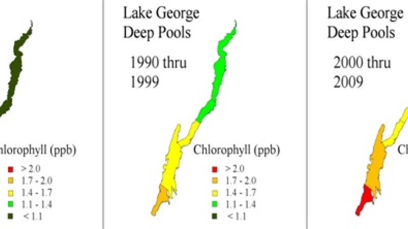
Chlorophyll levels (measured in parts per billion) have increased lake-wide by 33 percent over 30 years. Geographically, the increase shows a strong south-to-north gradient, with the differences between the basins of the lake increasing over time:
Nierzwicki-Bauer presented many other findings (and other graphics), but to a non-scientist (me), the above images were the most striking. Here are a few more of the "principal findings" she offered:
- South-to-north gradients exist in water quality with the southern more urbanized basin the most enriched
- The concentration of salts (Cl & Na) have nearly tripled over the past 30 years, with road deicing salts the primary source
- Changing chlorophyll levels may be due to increased nutrient and contaminant loading, changing population dynamics, or introduced species
- Late summer oxygen depletion and internal P cycling have only been observed in the Caldwell Basin
- Acid rain impacts have declined, with lower levels of acidity and sulfate and higher buffering capacity
- Surface water temperature has increased ~1.8 degrees Celsius between 1980 and 2009
The research was funded by Rensselaer and the FUND for Lake George. If you want to take a deeper dive into the results of the 30-year study, take a look at the full published report.